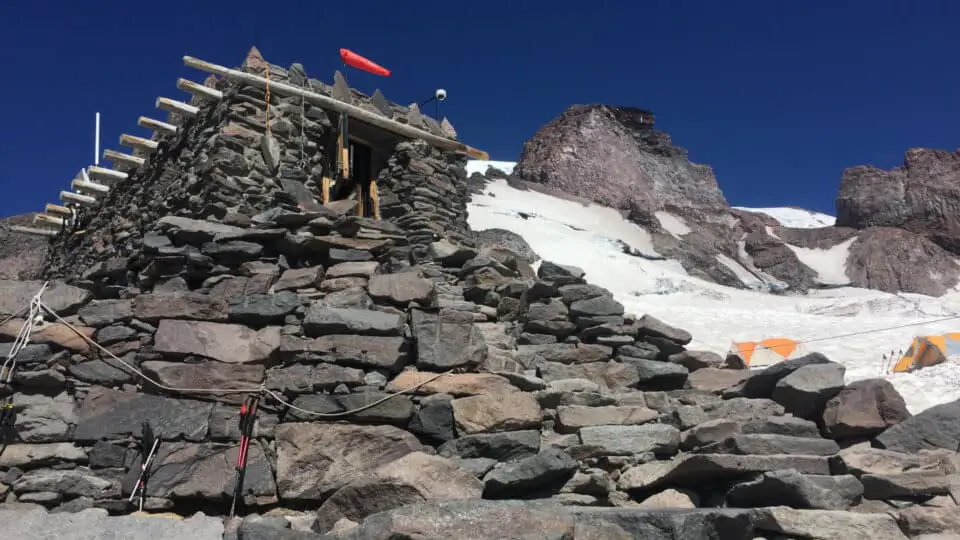
10,188 feet above sea level on the south flank of Mount Rainier lies Camp Muir: a cluster of small huts nestled into the saddle between the Gibraltar Ledges and the Beehive, above Anvil Rock and below Cadaver Gap. It’s the highest you can go on the mountain without a climbing permit, and one of the highest places in Washington State that you can get to without technical gear or expertise. The Muir Snowfield is deceptively doable and claims lives left and right like a little PacMan blindly devouring a few folks a year, from the ill-equipped noob who has no business being there in the first place to the accomplished mountaineer whose experience doesn’t make her impervious to white-out, hypothermia, or punching through the snow into the rapidly rushing Pebble Creek that roars down a part of the route with the uniquely unnerving sound of icy water moving fast somewhere way under your feet as you take careful eggshell steps across one of Mother Nature’s worst landmines.
Not Your Average Day Hike
A lot of people aren’t aware of the dangers inherent to this magical place, and run in to a lot of preventable problems. Fitness isn’t the issue; it’s only eight miles round trip with a gain of 4788 feet, and if it wasn’t on the side of a glaciated volcano it would be doable for any reasonably fit person. But things are different up there, and you should give this one pause before you just grab your water bottle and cell phone and decide to wing it. There is some stuff you need to bring, you’ll want to check the weather forecast for the days before and after your climb, and I recommend doing it in summer for first timers (not just for warmer temps but also for longer days and no time limit of when the park gates close). Starting out in Paradise, passing through all the families with toddlers taking Christmas-card-perfect photos, ladies in kitten heels tiptoeing gingerly on the paved walkways, and teenagers in Uggs and Vans slip-sliding everywhere and howling with laughter as they push each other down in the snow, you’ll feel it, the dividing line, somewhere around Panorama Point (6800 feet). The crowds will thin, the mountain will loom, the air will feel different, and you’ll know you’re boldly going where you have not gone before.
So how to prepare?
What To Bring
To be clear, I’m talking about a day hike to the buildings and back when I’m talking about what to bring on a trip to Camp Muir. If you’re camping or planning to summit, obviously you have lots more to consider. This is for the Everyhiker, the person who has outgrown Mt. Si and Granite Mountain, or is using Camp Muir as a test or training for bigger climbs and higher altitudes, or just wants to see what lies beyond the asphalt tourist trails.
Here’s a complete packing list:
- Eye Protection: sunglasses, glacier goggles, ski goggles, something with UV protection and hopefully a wraparound or side-blocking feature. Snow blindness is one of your number one concerns as you will be on an enormous exposed snowfield for a couple hours and should not attempt this trek without them no matter what.
- Satellite GPS device or a map and compass (if you know how to use a map and compass).
- Satellite emergency communication device such as a Garmin InReach.
- Chapstick and sunblock: Last June a few of us went up in near whiteout conditions; it was such a thick fog, and chilly, and we were so focused on navigating that we didn’t apply chapstick or sunscreen. The next day we were texting each other photos of our various blistered lips, swollen foreheads, and raccoon faces. One of our friends said he looked like a sock monkey the next day. I had lines from the straps of my poles laying across my wrists, and my face no longer matched my body. It was intense. The sunburn from snow, and snow at altitude, even when padded by fog, is as intense as any desert sunburn I’ve ever seen, and it feels worse because it sneaks up on you. Don’t let it.
- Water and/or a water filter: If enough snow has melted that Pebble Creek is visible, bring a water filter and fill up rather than carry the extra liters the whole way. That’s the halfway point. If you’re a big hydrator, you might want three liters for this trip, which is almost seven pounds of water. And in nice weather this won’t be an issue, but if you go when temps are near freezing, you won’t have a creek as a water source and your suck tube will likely freeze. Carry a Nalgene instead or in addition (some folks have luck putting their tubes in their jackets). But you do not want to run out of water or assume there’s a spigot at camp (there is not).
- Footwear: Boots are recommended, though if you’re confident in snow travel and have a favorite pair of GTX trail runners those could be fine on a warm day.
- Traction: Microspikes for sure, crampons if it’s early season and cold and icy. I’ve done snowshoes the entire way exactly once. 0/10 do not recommend.
- Poles: To make the descent safer and easier, and to lean on in the last 500 feet (you’ll see what I mean later). Sure they will help stabilize you on the snow and give you the extra oomph on the way up, but it can just as well be about the jello legs on the way down and how to stay upright.
- Layers: One or two more than you need. The temp swing can easily go from 60º to 20º and back, and you will be both exerting and taking breaks, so you’ll need layers that you can don and doff rapidly, and have spare if they get wet, if you get stuck overnight, or if someone else is having a layer emergency.
- Parka: Even in August, you will want your biggest floofiest puffy coat for sitting up at camp for a bit. This isn’t a tag and trot back down sort of day. Some of them are, but not this one.
- Hat with visor: Never instead of, but you might want one in addition to your eye protection.
- A Buff to help with sun protection as well as windburn, but also to help regulate your temp as your face goes back and forth from freezing to red hot.
- Backup battery for your phone
- More food than you think you’ll need
- Emergency gear: mylar blanket, bivy sack, firestarter, band-aids, duct tape, Advil
The Mountain Makes Its Own Weather
Due to its 35 square miles of glaciers and permanent snowfields, proximity to the Pacific Ocean, and prominence, Rainier has its own weather patterns that are very different from those down below. Checking your neighborhood weather or even the weather for Greenwater or Ashford, the small towns at its base, won’t give you any indication of what’s happening up there.
And instead of using a standard weather app, try the Mount Rainier Recreational Forecast
National Weather Service for very detailed, accurate, updated-often forecasts for Longmire, Paradise, Muir, and the summit, four well-known points on Rainier a couple-few thousand feet apart. I’ve even gone so far as to call the ranger station to ask people who are physically there for details, and their advice has been invaluable and their attitudes friendly.
It can’t be emphasized enough that the difference between fun and not, safe and not, and returning alive or not, often just comes down to the weather. There are so many resources online and through the National Park Service that you really don’t have an excuse to not get an accurate weather report.
When To Go
There are times to go, and times to not go. Rain, no. dark, no. If you don’t feel well, no. I would say that generally for newcomers July-September is best, with the caveat as always: “weather depending.” The main reasons:
- Weather is more hospitable in summer, with temps at Paradise often in the 60º to 75º range, and at Muir staying above 30º (generally) (there are exceptions) (the mountain does what it wants).
- In the summertime all the gates in to and inside the park are open 24 hours; you can get a predawn start if you’d like. During the winter, IF the gate from Longmire to Paradise even opens, the earliest it does so is 9 am, and it’s closed to uphill traffic at 4:00pm and to downhill traffic at 5:00pm, so the most you’ll have is 7 hours car to car, which might be fine if everything goes well but you can’t count on everything going well and they will absolutely lock your car in. It’s a good idea to wait until you have a good idea of your round trip time before you play gate roulette.
- Speaking of time, there is just plain more daylight in summer and you don’t want to feel rushed by the promise of impending darkness. Racing the sun is one of my least favorite mountain-related stress-inducers; you want to have a good time in addition to being safe, and worrying that you’re about to get swallowed by the dark is not fun at all.
- You’ll have an obvious bootpath and signage that isn’t buried in snow. While the route is fairly straightforward if you’re familiar with it, it can be nice if you aren’t to have a visual that goes with your map or GPS.
- There are more people around in the summer to follow, ask for directions, or seek help from. Not that one should rely on the presence of capable strangers but it can be comforting to see other humans nearby.
Winter can turn Rainier into a mini-Everest, with summit temps below zero, winds over 75mph, its snowy surface turning to ice, and treacherous roads that don’t always open due to any number of hazards from avalanches to debris to being too icy. Paradise gets an average annual snowfall of 670 inches a year, with the record being 1,122 (that’s 93 feet) over the winter of 1971-1972. Camp Muir temps are in the single digits most days from about November to April, with temps in the teens during spring and fall being commonplace. Pair that with no one around but yourself, and throw in a whiteout or an injury or the sun setting while you’re still trying to find your way down, and suddenly your day hike has become a potentially fatal nightmare.
Who To Go With
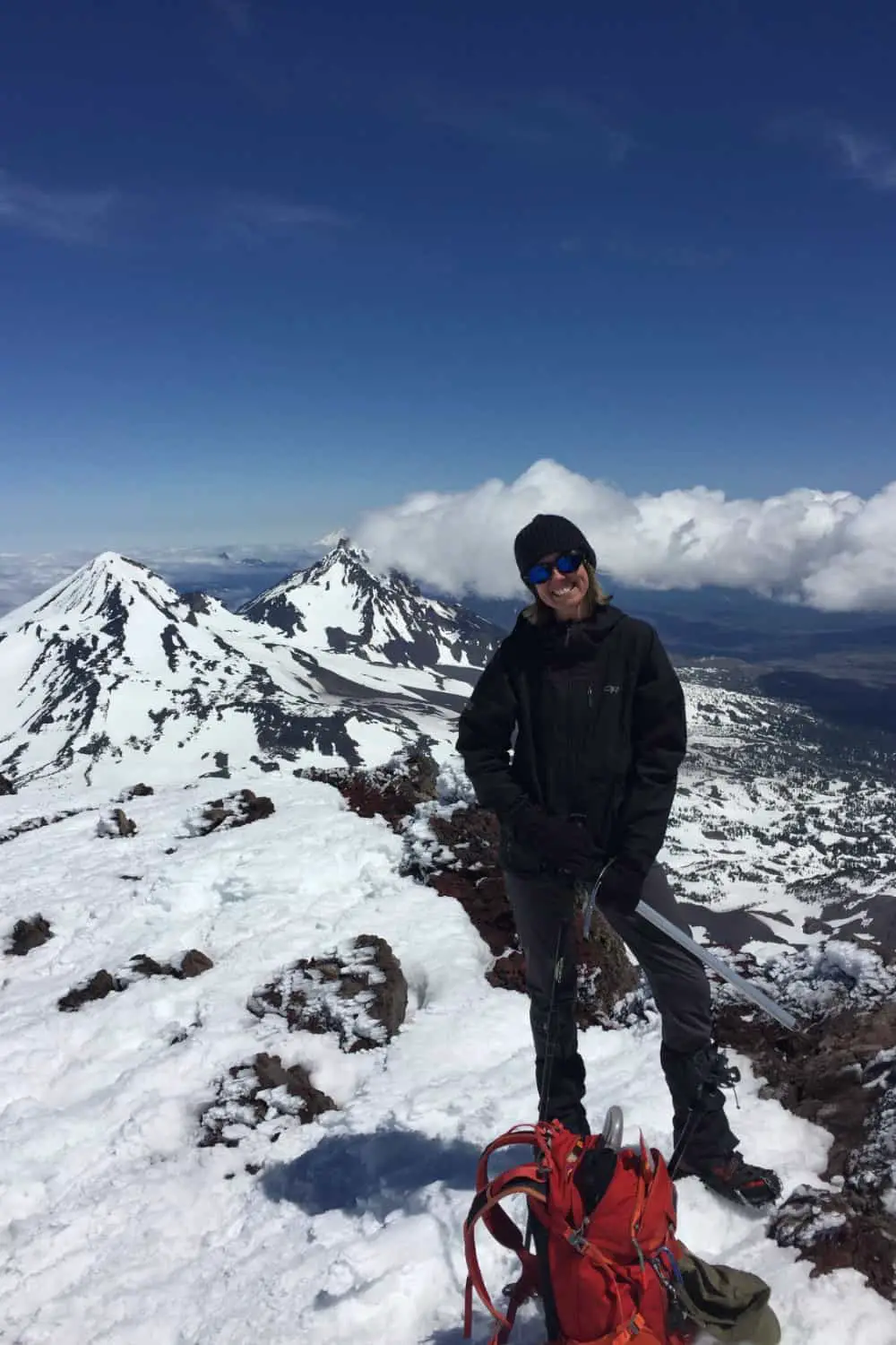
You’ll hear people say you should always go with someone for your first time, and I say if done in the right way, not necessarily. The first time I went I had been hiking almost exclusively solo for months so my senses, my first aid kit, my Garmin, my navigational tools, and my animal instincts were all very finely tuned. I chose a picture-perfect August day with no clouds in the forecast and got to the parking lot at 9 am when I knew crowds would be plentiful, and I had researched it so obsessively that I felt like I had been there before. The line of ants marching up the mountain was easy to follow and I was never more than a couple hundred yards from another person, well within shouting distance the whole time. So, solo but not. Plus I was prepared, I was focused, I had the gear.
Conversely, I know someone who went for the first time with someone who didn’t stay with them, so from Pebble Creek on down, he was alone — on a November day that deteriorated rapidly into whiteout conditions, no other people around, and a 3º overnight. He eventually made it home — a week after SAR found him and airlifted him to the local trauma center, after his heart stopped beating for 45 minutes and his core body temp dropped into the 60s and doctors worked like crazy to bring him back to life. Scars from being cut open, missing tissue due to frostbite, lingering brain and kidney damage. It was a freak miracle that he survived and you can’t always bank on that. So to clarify, “going with someone” means someone trustworthy, someone in whose hands you feel safe placing your life.
One June day (the sunburn day) three of us went together, and another five friends met us in the parking lot and we all headed out, despite the dense fog (no exaggeration, visibility was less than 20 feet. It was like being inside a ping-pong ball). Not even an hour in, due to these conditions, they turned around and went home. We kept on because our group had been many times and we all knew the route well, and had enough Garmins and phones and layers with us that we felt okay proceeding, but the other group was comprised of just one person who had been and four people who had never even seen the Paradise parking lot and weren’t comfortable with the conditions (both appropriate calls given each group’s experience level).
There are guided tours to Camp Muir (REI does one) if you’re still feeling iffy about the whole thing but still want to go. And iffy is fine; if ever there were a place for healthy fear this is it.
Red Tape
- If you don’t already have an America the Beautiful or MRNP parking pass, entrance to the park is $30 for the day.
- No permit is needed to go to Muir. If you intend to go beyond the buildings you’ll need a climbing permit; the application is available online and is $50 annually.
- Cell phone towers have been erected this year, so the service area has exp anded, but you should count on losing service in the parking lot and not getting it again till maybe the snowfield, then definitely the wooden table at Camp. If there is more now, great, but don’t count on it for safety or navigational purposes.
- The huts on the right as you approach are first-come-first-serve public; the one on the left is on perma-reserve to RMI (one of the guide companies). The one uphill is the ranger’s residence. Outhouses are public.
- November 1 to May 1 you must carry chains in your vehicle even if it’s AWD or 4WD, and they will ask to see them.
The Last 500 Feet
I mentioned leaning on your poles earlier. For some, just nearing 10,000 feet is enough to bring on some extra exhaustion, for others it’s the mindgame of not having landmarks against which to mark progress so it feels endless, for a few it’s just that four miles is a long ways. Regardless of how you get there, it seems most folks arrive at a point about 500 vertical feet from the buildings where it seems no matter how many steps you take, they don’t get any closer. You first see them at about a third of a mile away, and from that point on, I usually just put my head down, count steps to about a hundred, then stop. Over and over. And they don’t get closer. This is where the leaning comes in. You will eventually get there, it just takes some patience. Speaking of getting there…
Getting There
The park has four entrances: Carbon River in the northwest corner of the park, Stevens Canyon in the southeast, White River/Sunrise in the northeast, and Nisqually in the southwest. Only the Nisqually entrance is open year round, and even then, there’s no guarantee that the road will be open all the way up to Paradise during the winter months, which is where you want to park for a Camp Muir trip. MRNP updates their twitter feed at 6am every day with approximate opening times, but remember anything can happen with mountain weather and that includes road hazards (avalanche, ice, not enough plows, car accidents blocking, etc). I always check twitter on the drive down but come with a backup plan should the gate at Longmire be closed (cutting your drive to Paradise short by about 11 miles).
Also important to note that the Longmire gate allowing traffic to Paradise has strict winter hours (9am-4pm uphill, 9am-5pm downhill).
The easiest way to get to the Paradise parking lot is via SR706 through Ashford. Noteworthy items about the drive: 1.Scale Burgers in Elbe, and 2. the Whittaker compound in Ashford, which features a great snack bar/restaurant as well as a small but incredibly well-stocked gear shop (it’s like a mini REI but just for hikers and climbers with everything from mountaineering boots to crampons, gloves, water bottles, and touristy stickers). If you’re really tuckered out, rent a cabin, room, or space in the bunkhouse for a night and take advantage of their jacuzzi and cafe breakfast. Longer and more scenic drives can be made by entering at Stevens or White River and taking highway 123 through the park, but only from about May to October, as all park roads except the Nisqually-Paradise road close for the winter.
Entering at Nisqually, you’ll pay either a day fee ($30) or use your annual MRNP or America the Beautiful pass. 17 miles later, after driving through dense forest, next to the milky glacier silt water of Kautz Creek, crossing over the spectacular Glacier Bridge, and winding up to 5400 feet, you’ve arrived at your destination. Park, stretch, hydrate, change, meditate, whatever you need to do. There are restrooms both in and across the lot from the Jackson Visitors’ Center. Warning: on a low-visibility day and early in the morning you might be one of a small handful of cars in the lot; but during the summer it’s a circus of tour buses, smokers, day camps, and families with crabby toddlers on road trips. The guide groups and various mountaineering classes use this parking lot as well, the Standby Ambulance is usually parked by the rangers’ cabin, and The Paradise Inn is at the far end of the lot as well, making this parking lot quite the little Mecca of Rainier tourism. Be patient with the kitten heels and flip-flops set as you lash your crampons to your pack and set out for a place far beyond all that.
As you walk up the short staircase to the trail system, pause and read the John Muir quote etched into its steps: “…the most luxuriant and the most extravagantly beautiful of all the alpine gardens I ever beheld in all my mountain-top wanderings.” That’s saying a lot coming from someone who lived a life full of mountaintop wanderings. Get ready to feel the same awe and wonder as you climb to his namesake camp and take in the views and the vibes.
[wpgmza id=”10″]
Wendy Harrington is a California native who has lived in a small town at the foothills of the Cascade Mountains in Washington state since 2001. Her love of trail running and peakbagging has led her to summit all five Washington volcanoes, climb to the high points of three states, and put nearly a thousand miles a year on her boots. Her loves include ridgelines, saddles, granite, one-day pushes on big mountains, anything volcanic, long solo days, and objectives that push limits and test endurance.
