Mailbox Peak went from obscurity to celebrity within the past five or so years, likely a result of social media and all the folks working from home due to the pandemic AKA suddenly taking up hiking. If you’re looking for an easier hike to the same (yes, there’s an actual) mailbox on the summit, the New Trail provides a gently-graded, groomed option for the small price of a couple more miles. But if you’re looking to push your limits and find the outer edge of your cardio or quad comfort zone, the Old Trail is your jam. If you have heart, lung, knee, ankle, or attitude problems, it’s not your jam at all. There’s a masochistic pride in going Old Trail, and frankly not everyone can handle it.
The Old Trail
Gaining 4000 feet in two and a half miles is no joke; throw in a little route-finding and some incredibly uneven terrain and you have yourself a recipe for either disaster or triumph (or both). There are warnings posted at the trailhead; heed them. This trail is steep, rugged, and not always easy to follow. Some folks go with a Mailbox veteran for their first time to avoid getting off-track. Others use a navigation app or good old-fashioned compass and map. Summer weekends draw a crowd, while winter weekdays can be almost completely deserted.
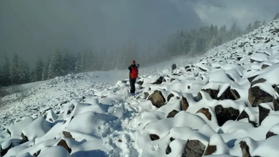
Mailbox Peak is open year-round and can provide good slopes to practice snow/axe skills in the winter while often not posing much avalanche risk at times when the rest of the area is on high-alert (but as always, check NWAC, be knowledgeable, be prepared, and be safe).
Pack plenty of water and an extra layer or two year round. You’ll want to have poles, gloves, snacks, sunscreen, and eye protection as well.
Bring also your determination, an open mind, and some good cheer; I have seen many folks sitting on boulders in varying states of emotional distress over how hard the Old Trail is taxing them, and I’ve overheard many arguments between the one who said it would be fun and the one sweating it out in Levi’s and Vans. Mailbox Peak crosses the line from normal day hike into something a little more alpine, a little more scrambly, almost more climb than hike.
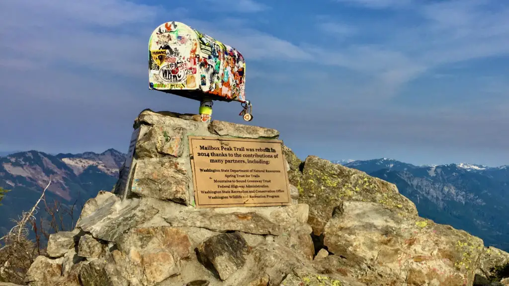
They say Mailbox’s Old Trail isn’t for the faint of heart or weak of knee, and they are right. It’s a brutal, rough-and-tumble, rude, muddy, rocky, rooty, hard-to-follow climber’s trail. It sets its sights on the summit from way down low and doesn’t relent until its crescendo: an actual mailbox, filled with an eclectic collection of ever-changing items (Rubber ducks? Plastic bust of Elvis? Whiskey? Letters, postcards, snacks, and once even a discarded wedding band have all been spotted as offerings to the Mailbox gods). Take something, leave something, or pass on the ritual; it’s up to you. Also found at the top: sweeping vistas of the North Bend and Snoqualmie area peaks, an in-your-face view of Mt. Rainier, the backside of the Teanaway, and on a clear day, Mt. Baker and Glacier Peak.
The Beginning
The first stretch is deceptively polite: a meandering trail running alongside a babbling brook surrounded by ferns and firs and foxglove, twisting and winding its way through the lower forest like any other trail in the area. After a hairpin switchback about a third of a mile in, you’ll immediately feel the pitch increase.
From this point, the trail gains about 3000 feet in the next 1.5 miles. Save for a couple slightly-less-steep-but-still-steep sections, you’re in for a quad-burning, sweat-generating, lung-bursting, adrenaline-pumping treat. It’s not unusual to see a look of disbelief on first-timers’ faces as they ask how much further, but it’s not the distance, it’s the effort and the unrelenting nature of the Old Trail that is the true test here.
The Middle
The middle section will feel like forever. Luckily there are enough points of interest to divert your mind from your body a bit: look for the one big flat rock on the right side of the trail (that’s one mile) or the blue sign posted high on a tree (“1000 vertical feet to stream”). It’s ok to take a break or two as you barely switchback directly up a crude, mulchy, root-braided footpath frequently blocked by fallen trees. When you notice that the ground cover has become slightly greener and lusher, you know you’ve made it past the halfway point.
Almost There
Two miles in, the Old Trail intersects with the New Trail. Here you can either give your legs a break and turn right, relaxing up a few well-maintained switchbacks to the boulder field, or barrel straight ahead, crossing through the intersection and straight into the woods for some more unrefined high-incline shortcut stuff, now that you’ve become accustomed to it.
Either way, you’ll pop out of the trees as if from a doorway and come face to face with an enormous talus field. This is the start of your last half mile and 960 vertical feet. After having come up via all the slippy-slidey dirt/mud/roots, these stable, easy-to-navigate, pillow-sized boulders are a relief. For many, finally having a view other than tree trunks and dirt is inspiring and motivating. Trotting east on these rocks, you’ll switchback a few times before the talus field peters out and transforms into a more alpine meadow terrain decorated with beargrass and wildflowers. Look west for views of Mounts Si and Teneriffe.
The End
Yes, it does end. The summit comes into view and the path returns to its former primitive and precipitous self. It covers the last 500 vertical feet in less than a quarter mile, giving you the first glimpse of the box just a minute before you reach it. Don’t stop! And don’t be surprised if you hear the “Rocky” theme in your head as you top out at the summit. If you’re standing next to that box, you’re a fighter and you’ve won this round. Nice work. Who knew feeling this bad could feel so good?
The Sweet Smell Of Victory (AKA Body Odor)
On a summer weekend day, there can easily be a couple dozen folks up there, cheering on your last steps, taking photos of and with the mailbox, picnicking, stretching, resting, or pointing out neighboring peaks. On a winter weekday, if you’ve braved the snow and ice (spikes, poles, gloves, and extra layers recommended) you could very well have the summit to yourself. Either way, pause here for a bit.
Take in the 360-degree views. Admire the big volcanoes. Gaze out at the jagged horizon of the Olympic range to the west. Try to identify the peaks of the Stuart range and North Cascades off the backside of the box. Thank your feet and legs for getting you up there, and then apologize to them, as they are about to carry you back down. Take your time, watch your step, and bask in your accomplishment and the confidence boost you get from doing something not everyone can do.
The Aftermath
The next day, rest a little and know that your legs will forgive you and your soul thanks you. Mailbox Old Trail carries with it every ounce of “no pain, no gain” and “anything worth having is worth fighting for.” And don’t be surprised if you want to do it again as soon as the pain wears off, sort of like childbirth, or a toxic relationship.
How To Get There
From i90, get off at exit 34, just past Mount Si. You’ll see the semi trucks lined up at the offramp as their drivers nap. Go left. The best part about this offramp is the Popeye’s Chicken & Waffles, but the mini mart is also a real win here in case you forgot snacks or batteries. Keep going until your right turn at Middle Fork Road. Follow Middle Fork Road for a few miles, taking the upper fork where it splits. Make a left at the Valley School. Here’s where cell service vanishes. Parking is on your right not quite a mile in. If you think this hike might take you awhile, park in the lower lot. They are serious about locking that gate at dusk. The upper lot has restrooms, the lower does not. A Discovery Pass is required for both.
You’ll see another gated road to the left of the upper lot; walk that to get to both trailheads. New Trail comes first, then a few hundred yards later, Old.
[wpgmza id=”6″]
Source
Washington State Department of Natural Resources: Government Website
Wendy Harrington is a California native who has lived in a small town at the foothills of the Cascade Mountains in Washington state since 2001. Her love of trail running and peakbagging has led her to summit all five Washington volcanoes, climb to the high points of three states, and put nearly a thousand miles a year on her boots. Her loves include ridgelines, saddles, granite, one-day pushes on big mountains, anything volcanic, long solo days, and objectives that push limits and test endurance.
