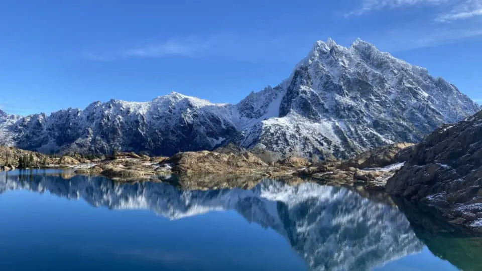
Nestled deep in the Teanaway River Valley is a brilliant royal blue lake in a granite basin featuring Mt. Stuart as its backdrop and ample opportunities for scrambling, rock climbing, and goat-watching around its perimeter. At just a few hundred feet across, it’s not a big lake size-wise, but it packs a wallop of a punch view-wise. First of all, it boasts a dramatic in-your-face view of Mt. Stuart, the crown jewel of the Stuart Range and the second tallest non-volcanic peak in Washington. The cobalt of the lake pops hard against the terracotta red of the surrounding shoreline rocks, which both contrast like crazy against the muted gray of the mountains in the near distance. And as if that wasn’t enough of a visual feast, it’s one of the few semi-easy-to-get-to places you can find the elusive larch tree, a rare breed of conifer that turns bright golden yellow for about two weeks in early October and is only found at certain elevations at certain latitudes in certain conditions. While only a nine mile round trip, it’s easy to spend an entire day here basking on the rocks, soaking it all in.
A Reminder: Wilderness Does Contain The Word “Wild”
Starting out from the Esmeralda Basin trailhead, the first part of the trail is somewhat uneventful and switchbacky, with a decidedly more arid vibe to it than the west-of-Snoqualmie-Pass hikes: trees are fewer and farther between, the understory lacks the ferns and other vibrant greenery that is a staple over here in the wetlands, and gnarled exposed roots have been bleached bone-white in the sun, giving them a southwestern/Georgia O’Keefe vibe. Though I can’t say this stretch will ever seem chill to me again, having been the site of my first up close and personal cougar encounter.
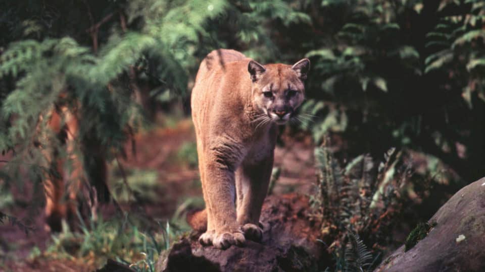
Which I should probably pause here and share with you guys, because, one, we later found out that there were numerous sightings of likely the same kitty in the same area that week, and, two, because it was one of the most unsettling experiences I’ve ever had, on or off the trail. It was well before sunrise on a perfect September morning and my best adventure friend and I were just boppin’ along at a decent clip, headlamps on, the rhythm of our stride in a perfect groove, when we came around a bend in the trail and she suddenly slammed on her brakes and grabbed my arm. I looked up in time to see two perfectly round unwavering eyes reflected in the light, just a couple feet off the ground, on the trail not twenty feet from us. We froze, it froze, and my mind went fast through the rolodex of animals it could be: Deer? Too low. Bear? Too small. Marmot? Too big. Coyote? Eyes all wrong. Stray dog? Too quiet. Because that was the thing: there was dry brush all around us on both sides of the trail; any other animal we would have heard. Deer and dogs and bears crash around like they’re trying to see how much noise they can make, but this guy was one hundred percent silent. In a motion that can only be described as feline, the eyes dipped and swiveled away, a swooping hanging motion with a stealthy fluid grace not seen in other animals, and we stood back to back watching the hillside just above the trail, our headlamps catching those eyes every so often, still no sound at all as it slinked away. We waved our poles around, we made noise, we didn’t run, and we waited for the people we had seen in the parking lot that we knew would be there soon. We walked as a very slow and very aware foursome, parting ways when the sun came up and the hairs on the back of our necks finally laid back down.
Anyway.
I just wanted to drive home the fact that it’s remote, it’s real wilderness, and it’s not without hazards, despite it feeling tame and welcoming on good weather weekends. There’s no cell service once you turn onto Teanaway Road, 22 miles from the parking lot. There are animals. The road is not paved. Trees fall across the road at times, preventing people from coming in, or getting out. This isn’t your family-friendly Rattlesnake Ledge, this is the Alpine Lakes Wilderness, and you need to be self-reliant and well-prepared.
That being said, if you’re having reservations about going solo, wait till about 9 am on a Summer Saturday and your biggest problem will be how far down the road you’ll wind up parking. For a lot of solo hikers that are comfortable with less remote trails that have cell service, the Teanaway area is a step toward being remote and solo, which for a lot of women is both a dream and a nightmare, as we crave the solitude but fear the unknown. Ingalls gives you a preview into that world while remaining mostly in this one.
The Trail
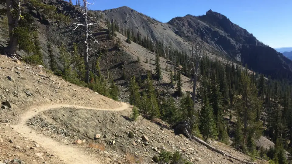
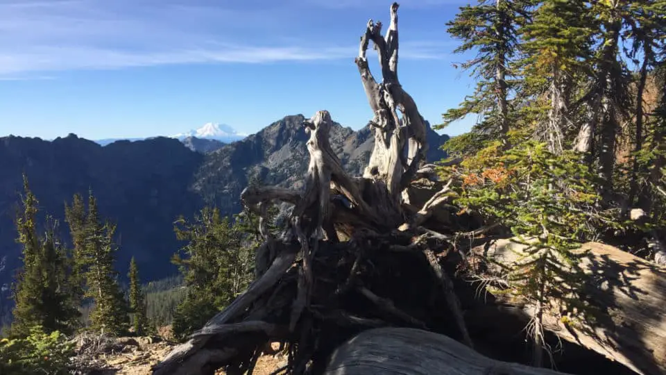
As I was saying, the beginning of the trail is fairly nondescript. Not to say it isn’t beautiful in its own way, just that the first bit isn’t your big-money photo-op section, it’s more a means to an end. Esmeralda Creek can be heard on your left as you start out with a decent uphill grade, with a sign giving you your first choice at about a half mile: Left to Esmeralda Basin or right to Ingall’s Way. Go right. Moving away from the creek and toward the top of the ridge, you switchback up the hillside on a well-defined trail, dry brushy shrubs and sporadic pines eventually giving way to wide open spaces, rocks of all shapes and sizes, and grand views of the Teanaway peaks, Mt. Rainier, and Mt. Adams. Don’t be fooled by the sign pointing right to Long’s Pass about a mile and a half in; keep going straight and at about the three mile mark you’ll hit Ingalls Pass. You’re headed into the Alpine Lakes Wilderness, and the change is palpable: the air feels drier, and the views are even more dramatic, with the jagged Stuart Range now in sight. The sound of pikas and the sight of marmots signals your entry to a new ecosystem, as does the view down into Headlight Basin, a vibrant mossy green meadow decorated with tiny streams, northwestern wildflowers, and larches.
The Larch March
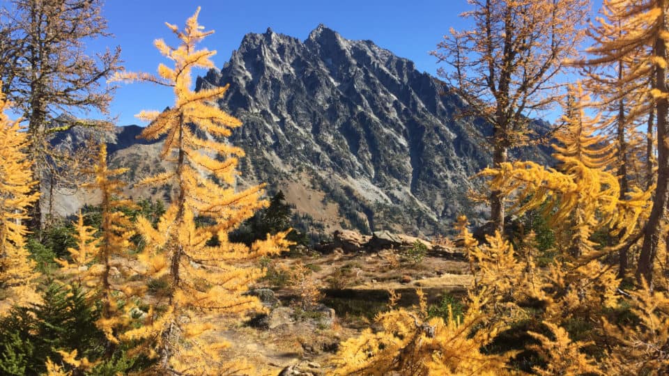
There’s a phenomenon that occurs in the PNW in late September to early October, often referred to as Larch Madness, in which this rare deciduous conifer turns bright golden yellow just before losing all of its foliage. This phase of their cycle lasts just a couple of weeks, and can only be found in places where the air is dry enough and cold enough. There are two types of larches, the Western and the Subalpine. Western larches can grow to around 170 feet tall and and are found on north-facing slopes between 2,000 and 5,500 feet in elevation. Subalpine larches reach around 70 feet in height and are found higher up, at around 5,500 to 7,500 feet. Larches most commonly grow on the eastern side of the Cascades, because they need a lot of sunlight and thrive in young forests recovering from fires. Western Washington is too gray, too wet, and not fire-prone enough for them to flourish. For folks not prepared to travel deeper into Washington’s northeastern backcountry, Lake Ingalls provides somewhat easy access and is only two hours from Seattle.
To The Lake
This saddle provides a windbreak and is a great place to stop and regroup and snap a few photos. In the late fall this might be where you put spikes on if you’re here after the first snow. Dropping into Headlight Basin from the top of Ingalls Pass, head left down the more obvious trail (there is a trail to the right but it requires some routefinding and can be a little rough and rugged). Suddenly the parking lot and the nearby town of Cle Elum and wherever home is for you all feels very far away and nearly forgotten as you meander your way through this alpine playground and across to the other side. Where the trail is faint, small cairns will help direct you, but it’s also somewhat intuitive: just make it to the other side of the rocks, as they are the backside of the rocks that surround the lake, and eventually there is no trail anyway, you’re just walking over these tremendously huge boulders. I wouldn’t quite call this section a scramble, but I also wouldn’t do it while balancing a glass of champagne on my head either.
Coming up to the top of this rocky area you get your first peek of the lake. Yes, it really is as blue as it looks in pictures. Yes, you might gasp aloud seeing 9,415′ Mount Stuart centered over it, looming, its ominous crags and points and couloirs and pointy granite creating a ridiculously visually compelling mountain that I personally can never seem to look away from. So walk down just a handful of yards and find a place to sit and stare. There is plenty of shoreline that even with lots of other people there you can spread out some. Walking to the other side of the lake is an option as well, which affords perfect views of the three Ingalls Peaks, which top out at 7,500, 7,640, and 7,662 feet respectively.
The Goats
Sit here long enough and you are likely to have some goat company. Herds of big shaggy white mountain goats have made this area their home long before we showed up, and they often come oddly close to check us out. While usually harmless, they are still wild animals that can still react in primal and unpredictable ways, so give them their space, don’t feed them, and don’t approach them, and you will likely coexist quite well.
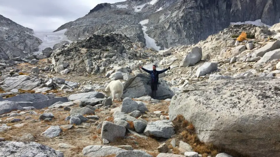
- Please heed the No Dogs Allowed rule. It’s in place not just to protect the fragile meadows or prevent your overly friendly four-legged friend from annoying hikers looking for peace and quiet, but mostly to keep your pooch from the goats. A couple of years ago, a guy brought his dog to Lake Ingalls, not sure if he just thought the rules didn’t apply, or that his dog was different, or if he just hadn’t done his research and didn’t want to leave him in the car or turn around and leave after having driven however long, but in any event, the upshot was an off-leash German Shepherd was chasing a pack of goats on the rocks above the lake, and the goats corralled the dog to a precarious spot and then one of them butted him off. Internet rumor had both the owner carrying his dog to safety, and it being an unsurvivable fall. I wasn’t there that day, and I can’t seem to find anything confirming the outcome, so I choose to believe pup just had a little wrist cast or something. Those goats are fiercely territorial and can be terrifyingly aggressive. Please have your pets sit this one out, for their own safety.
- They like the smell of pee. A lot. If there are goats around, seriously consider holding it until the coast is clear, because the pee-smell brings them your way like a pspspsps does with cats.
- I hope this goes without saying but please do not feed them, for obvious reasons.
- Sometimes they stand like gatekeepers right where you’re trying to go. it’s best to defer to them and give them space, backing away a bit and not holding prolonged eye contact. Goats generally won’t attack unprovoked so just be as unobtrusive as you can, moving slowly, being quiet, and giving room. I know they look big and lumbery and silly, but they can be surprisingly fast, strong, and dangerous, and if you challenge them, they are liable to charge at you, and their horns are sharp. I’ve never heard of a goat charging someone who wasn’t blatantly bringing it on themselves.
- Should one become aggressive, get big and loud. Wave your jacket overhead, hold your poles high, whatever you can do to seem large. Don’t come at the goat, don’t run away. And clear out of the area as soon as is safe.
Getting There
From eastbound I-90, take Exit 85. Cross the freeway on the overpass and turn right onto Highway 970. Drive 970 for 7 miles and turn left on Teanaway Road.
7.1 miles later, bear right as the road becomes North Fork Teanaway Road. 5.9 miles past this fork, where the road becomes unpaved, take the right fork to Forest Road 9737. Drive 1.1 miles and stay left at the fork signed Beverly Campground. Continue on this road a further 6.7 miles and keep right at a fork signed Trail 1394. Drive another 1.7 miles to the trailhead. It is 22.5 miles to the Esmeralda Basin/Ingalls Lake trailhead from the turn off of Highway 970. The unpaved portion of the road is normally fine for any vehicle, but high-clearance is best, at it is often potholey or washboarded depending on how long its been since its been maintained. The parking lot requires a NW Forest Pass. If the trailhead is full, park only on the west side of the road to allow safe traffic flow.
Source
USDA Forest Service: Website
Wendy Harrington is a California native who has lived in a small town at the foothills of the Cascade Mountains in Washington state since 2001. Her love of trail running and peakbagging has led her to summit all five Washington volcanoes, climb to the high points of three states, and put nearly a thousand miles a year on her boots. Her loves include ridgelines, saddles, granite, one-day pushes on big mountains, anything volcanic, long solo days, and objectives that push limits and test endurance.
